Wildfires are intensifying and spreading at unprecedented rates, reshaping entire ecosystems and threatening communities once considered safe. As the flames subside and recovery efforts begin, many overlook a critical adaptation tool that could transform how society prepares for future disasters. Post-fire assessment provides actionable intelligence needed to build genuine resilience against an increasingly volatile climate.
The Growing Economic and Environmental Toll of Wildfires
Modern wildfires impose devastating costs that extend far beyond charred landscapes and destroyed homes. Understanding the full scope of damage requires examining both the immediate financial burden and the long-term environmental consequences that ripple through ecosystems for years after containment.
Quantifying the Staggering Financial Burden
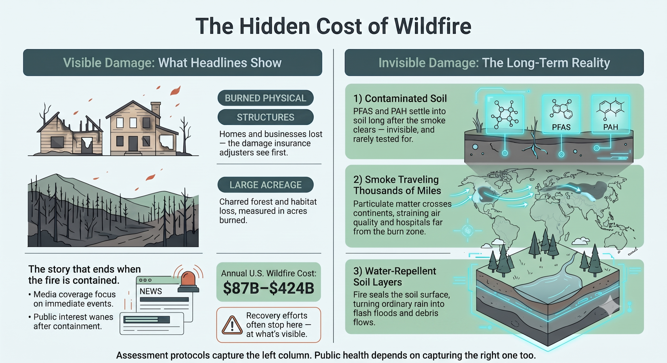
The economic impact of wildfires has reached unprecedented levels. Annual costs range from $87 billion to $424 billion in 2022 dollars when accounting for property damage, loss of life and healthcare expenses. Even these staggering figures likely underestimate actual losses after 2016, as development continues pushing into fire-prone areas and blazes grow more intense.
Homes and businesses take years to rebuild, while farms lose entire harvests, and critical infrastructure sits damaged. As communities recover from the immediate destruction, healthcare systems absorb mounting costs from treating smoke-related respiratory illnesses. At the same time, property insurance markets are becoming increasingly unstable in high-risk regions.
Assessing the Lasting Environmental Damage
Atmospheric damage from major fire events creates pollution on a massive scale, with forest fires annually emitting millions of tons of smoke particles and greenhouse gases. This feeds the climate crisis, driving these disasters while releasing stored carbon within hours.
The pollution doesn’t stay localized either. Particulate matter travels thousands of miles, degrading air quality far from the flames. Cities hundreds of miles away experience hazardous breathing conditions, hospitals see spikes in respiratory emergencies, and vulnerable populations face prolonged exposure to toxic air that creates public health crises across entire continents.
Shifting From Reaction to Proactive Assessment
Federal agencies have developed structured systems to evaluate fire-damaged landscapes and coordinate recovery efforts. For instance, the Burned Area Emergency Response program addresses stabilization needs on federal lands after containment, with teams working to minimize threats to life, property and natural resources through urgent recovery actions.
These assessments capture valuable information, allowing communities and agencies to set the foundation for smarter adaptation strategies. Each study documents patterns in damage severity and identifies infrastructure vulnerabilities while revealing which ecosystems prove most resilient under extreme conditions.
The challenge lies in transforming post-fire data into long-term planning tools. Many regions conduct thorough assessments but fail to integrate findings into zoning decisions, building codes or restoration priorities. Breaking this pattern requires viewing post-fire evaluation as the first step in a continuous learning cycle rather than the final act of crisis management.
The Science of Modern Fire Assessment
Scientific teams deploy sophisticated measurement techniques to understand how fire transforms landscapes, generating detailed datasets that reveal recovery patterns and identify hidden vulnerabilities. The methods range from hands-on field measurements to satellite imagery analysis, each contributing unique insights about post-fire conditions.
Measuring Soil Erosion and Landscape Stability
Scientists track recovery by measuring erosion through sediment yield collected from hillslope plots, which provides concrete data on treatment performance. Infiltration capacity measurements serve as another key indicator, revealing how soils and watersheds respond after fire.
Additionally, hydraulic recovery analysis helps determine whether landscapes can handle rainfall without catastrophic runoff. Fire fundamentally alters soil structure, sometimes creating water-repellent layers that prevent moisture absorption and persist for months or years. These changes turn ordinary rainstorms into debris flows that threaten downstream communities, which is why monitoring allows teams to prioritize stabilization efforts where risks run highest.
Tracking Vegetation Recovery With Remote Sensing
Satellite technology offers powerful tools for monitoring post-fire landscapes across vast areas, with the Normalized Difference Vegetation Index providing quantitative measurements of greenness and plant regrowth over time. Teams evaluate burn severity using spectral indices such as the differenced Normalized Burn Ratio, while geographic information systems manage and analyze the complex spatial datasets generated by these assessments.
Certain plant communities bounce back quickly while others struggle for years, patterns that only become visible through remote sensing. Some areas show unexpected resilience despite severe burns, suggesting microclimate factors or soil conditions that buffer against extreme heat. Documenting these patterns helps scientists predict which restoration strategies will succeed in similar environments and where natural recovery might proceed without intervention.
Uncovering Hidden Dangers in Post-Fire Soils
Chemical contaminants settle into residential soils, creating invisible threats that persist long after the smoke clears. For example, polycyclic aromatic hydrocarbons form when organic materials burn, while per- and polyfluoroalkyl substances (PFAS/PFOA) from firefighting foams infiltrate the ground.
PFAS/PFOA pose particularly serious concerns, as exposure may decrease fertility or cause cancer, along with childhood developmental delays and reduced immune function. Detecting and addressing these hazards requires thorough soil testing that goes beyond assessing visible damage.
Communities rebuilding after fires often focus on structural repairs while these chemical hazards go unexamined. Children play in contaminated yards, and gardens uptake toxins through their roots, introducing contaminants into food chains. Fire assessment protocols that include soil chemistry testing protect public health by identifying these hazards before people return home.
Find out more about the environmental impact of wildfire’s and how climate change plays a role in this video from CBC News.
Integrating Traditional Ecological Knowledge for a Holistic View
While modern science reveals hidden chemical threats, Indigenous communities have managed fire-prone landscapes for thousands of years, developing practices that prevent such contamination in the first place. Combining these time-tested approaches with contemporary assessment methods creates a more complete understanding of how ecosystems and fire interact.
Reviving Cultural Burning Practices in North America
Cultural burning involves intentionally lighting smaller, controlled fires to achieve specific land management goals. Indigenous peoples across North America have used fire this way for millennia, clearing land for crops, travel routes and ecological productivity.
By reducing fuel loads that could feed catastrophic blazes, these fires once played a vital role in preventing the kinds of landscapes we see burning today. But modern fire suppression policies disrupted these traditions for over a century, allowing dangerous fuel accumulations that now drive megafires. Reintegrating cultural burning requires collaboration between tribal practitioners and land management agencies, and the data strongly support this shift.
Research shows that removing dead or dry overgrowth through burning and thinning decreases wildfire severity by 62% to 72%, far more successfully than thinning alone. Some regions have responded by creating formal programs that support Native fire stewards and provide resources for controlled burns guided by traditional timing and Indigenous knowledge.
Global Lessons in Indigenous Land Conservation
Indigenous lands in Brazil conserve 13% of the national territory while serving as powerful buffers against deforestation and widespread wildfires. Communities like the Krahô of Tocantins and the Xavante of Mato Grosso have maintained these landscapes for generations, using fire management that protects both ecosystem health and human settlements.
These territories consistently show lower fire intensity and faster recovery than neighboring lands under standard management. Traditional fire practices create landscape mosaics with varied vegetation ages and densities, which naturally limit fire spread across vast areas while providing the diverse habitats many species need to thrive.
Blueprints for Building Fire-Adapted Communities
Turning fire assessment findings into actual resilience requires more than data. Regional collaborations and infrastructure improvements transform those insights into protective measures, but the transition demands political will, sustained funding and coordination across multiple jurisdictions.
Fostering Collaborative Action and Governance
The Rogue Basin shows what happens when organizations work across boundaries to build adaptive capacity. These collaboratives bring together agencies, nonprofits and private contractors who pool resources and share information across jurisdictional lines. By elevating local voices and directing funding toward landscape-scale projects, they can address the vulnerabilities identified in various assessments.
Federal land managers work alongside state forestry departments, county planners and private landowners, breaking down silos that typically prevent unified action. Sharing insights allows these groups to treat fire risk as a landscape-level challenge rather than isolated property concerns. Other fire-prone regions can adapt these models to their own circumstances, learning from communities that have successfully made the shift.
Engineering and Building for a Hotter Future
Structures built with fire-resistant materials and building methods stand a far better chance of surviving a wildfire. That means choosing metal or tile roofs, noncombustible siding and sealed eaves for critical protection, while immediately removing dry vegetation around buildings to keep flames away.
Building codes in fire-prone areas increasingly mandate these protective measures for new construction. The harder challenge lies in retrofitting the existing homes that make up most communities.
Programs offering financial incentives or technical assistance help homeowners overcome cost barriers. Combined with landscape-scale fuel reduction informed by assessment data, these physical improvements can prevent entire neighborhoods from burning.
From Data-Driven Assessment to a Resilient Future
The climate crisis demands that communities move beyond reactive recovery toward intentional adaptation. Post-fire assessment becomes strategic intelligence when its findings guide restoration priorities, infrastructure investments and policy updates. Communities that systematically apply these insights will face future disasters with landscapes and systems designed to withstand them.
Frequently Asked Questions
What does post-fire assessment actually involve?
It combines field measurements and remote sensing to track how a landscape is recovering. Teams measure soil erosion and infiltration capacity on the ground, while satellites provide vegetation regrowth data (via the Normalized Difference Vegetation Index) and burn severity mapping (via the differenced Normalized Burn Ratio). Together these tools show which areas are stabilizing, which remain at risk of debris flows, and which ecosystems are recovering fastest.
What can homeowners and communities actually do with post-fire assessment data?
The data is meant to inform concrete action: fire-resistant building materials (metal or tile roofs, noncombustible siding, sealed eaves), defensible space around structures, updated building codes for new construction, and retrofit assistance programs for existing homes. Regional collaboratives — like the one in the Rogue Basin — also use assessment findings to coordinate landscape-scale fuel reduction across agencies, private landowners, and local governments rather than treating fire risk property-by-property.
How does Indigenous cultural burning reduce wildfire severity?
Cultural burning uses smaller, intentionally set fires to clear excess fuel before it can accumulate into the dense, dry overgrowth that feeds megafires. Research cited in the article found that combining burning with thinning cuts wildfire severity by 62–72%, a far bigger reduction than thinning alone. Decades of fire suppression policy interrupted these practices, allowing fuel loads to build up — which is part of why megafires have become more common today.
What can homeowners and communities actually do with post-fire assessment data?
The data is meant to inform concrete action: fire-resistant building materials (metal or tile roofs, noncombustible siding, sealed eaves), defensible space around structures, updated building codes for new construction, and retrofit assistance programs for existing homes. Regional collaboratives — like the one in the Rogue Basin — also use assessment findings to coordinate landscape-scale fuel reduction across agencies, private landowners, and local governments rather than treating fire risk property-by-property.